
Your cart is empty Continue Shopping
Highland outdoor landscapes: a field guide for travellers
The Scottish Highlands contain nine principal types of outdoor landscape: mountain summits and plateaux, glens and straths, lochs and freshwater features, blanket bog and peatland, upland heath and montane grassland, rock outcrop and scree, calcareous grassland, limestone pavement, woodlands and riparian strips, and coastal fringes and islands. Together, these form one of Europe’s most varied upland environments, shaped by ancient geology and repeated glaciation. The Scottish Highlands are typically described as a mix of mountains, peat bog, woodland, heathland, grassland and freshwater, with dramatic scenery created by these interacting elements.
A few representative places anchor the whole picture:
- Ben Nevis and the Grey Corries — classic Highland Summits terrain, with rugged peaks, corries and scree
- Cairngorms National Park — the largest example of high plateau in Britain, plus extensive blanket bog and montane heath
- Isle of Skye — combines coastal fringes, rock outcrop, upland heath and dramatic ridge scenery in a compact area
- Loch Lomond & The Trossachs — upland glens, freshwater lochs and riparian woodland within easy reach of central Scotland
Knowing these types helps you choose where to go, what to expect underfoot, and which seasons reward a visit.
Key takeaways
The Scottish Highlands contain nine distinct outdoor landscape types, each shaped by specific geology and glaciation, and each best visited in a particular season with appropriate kit and preparation.
| Point | Details |
|---|---|
| Nine principal landscape types | Summits, plateaux, glens, lochs, bog, heath, rock, woodland and coastal fringes each have distinct recognition cues. |
| Use the NatureScot LCT map | Downloadable LCT PDFs give consistent landform, vegetation and perception notes for every Highland area. |
| Season determines what you see | Breeding birds peak April–June; heather colour peaks July–September; deer rut runs September–October. |
| Protect sensitive habitats | Stay on paths across blanket bog and montane communities; avoid fire on peat; close deer-exclusion gates. |
| Skyehighlandstours | Private guided tours sequence contrasting landscape types efficiently, with local safety and interpretive knowledge built in. |
Table of Contents
- What are Landscape Character Types and why do they matter?
- The nine types of highland outdoor landscapes explained
- Key upland habitats and the wildlife you are likely to find
- How geology and glaciation shaped the Highland landscape
- Practical advice for visiting different Highland landscape types
- A guide’s perspective on reading the Highland landscape
- See these landscapes with a private guided tour
- Sources
- FAQ
What are Landscape Character Types and why do they matter?
Scotland’s national Landscape Character Assessment (LCA), managed by NatureScot, divides the country into mapped Landscape Character Types (LCTs). Each LCT is a consistent, named category defined by its landform, vegetation, land use and visual character. NatureScot publishes downloadable PDF descriptions and mapped polygons for every LCT, so planners, conservationists, educators and travellers can all work from the same framework.
For travellers, LCTs do something useful that a general map cannot: they tell you what a place feels like before you arrive. The Highland Summits LCT, for instance, signals rugged peaks, open skylines and sparse settlement. The Summits and Plateaux – Cairngorms LCT signals something different: broad rolling ridges, wide horizons and extensive montane communities rather than dramatic pointed peaks. Knowing the difference shapes your kit list, your route choice and your expectations.
LCT descriptions are practical tools for planners and educators as well as for travellers, linking conservation objectives with public appreciation of regional identity and cultural heritage.
NatureScot recommends using LCT descriptions to connect conservation priorities with visitor understanding, which means the same PDFs that inform a planning application can also help you interpret a view from a hillside.
The nine types of highland outdoor landscapes explained
The sections below follow the nine principal types. For each one you will find the key landform cues, characteristic vegetation, notable species, representative sites, and a short visitor note. A summary table follows the descriptions.
1. Mountain summits and plateaux
The Highland Summits LCT is defined by rugged peaks, steep slopes, corries, scree and a largely open, sparsely settled landcover. Many named high peaks sit within this type. Ben Nevis, the most visited example, is a notably high summit; the Torridon peaks and An Teallach represent the more remote end of the spectrum.
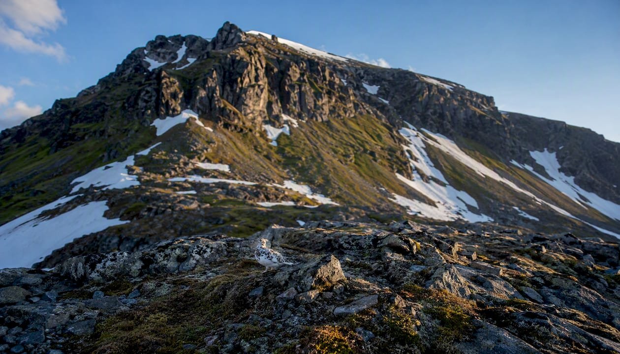
Vegetation is sparse above 900 m: wind-clipped woolly hair-moss, three-leaved rush and patches of stiff sedge replace the heather of lower slopes. Look for ptarmigan in their cryptic grey-brown summer plumage, and mountain hare in white winter coat. Snow can persist in north-facing corries well into June.
Visitor note: Navigation on open summits requires map and compass skills. Cloud can descend in minutes, and wind chill at altitude is severe even in summer.
The Summits and Plateaux – Cairngorms LCT covers a different character: broad rolling ridges and wide plateaux rather than pointed peaks. The Cairngorm plateau above 1,000 m is the largest area of high ground in Britain, supporting extensive montane communities and large areas of upland blanket peat. The visual experience here is one of vast, open horizons rather than dramatic verticality.
2. Glens and straths
Practitioners distinguish these two valley types clearly. Glens are narrow, steep-sided valleys with confined views and often remnant native woodland along their burns. Straths are broader, loch-filled valleys with more open panoramas and a longer history of agricultural settlement. The distinction matters for access planning: a glen walk is typically a linear route with limited escape options; a strath offers more lateral movement.

The Upland Glens LCT for Loch Lomond & The Trossachs describes narrow enclosed valleys with remnant Caledonian pine and native broadleaf woodland, tributary burns and classic channelled views. Glen Affric and Glen Coe are among the finest examples. For a curated list of visitable valleys, the Highland glens guide covers the most rewarding routes.
Visitor note: Autumn (September–November) is the best season for colour and red deer rut. Spring burns run high and fast after snowmelt — ford crossings need care.
3. Lochs and freshwater features
Lochs range from the vast (Loch Ness, 37 km long) to the tiny corrie lochans perched at 900 m. Their character shifts with altitude: lower glen lochs are often dark with peat-stained water and fringed with alder and willow; high corrie lochs are clear, cold and almost lifeless by comparison.
Ospreys fish the larger lowland lochs from April to August. Slavonian grebes, now rare, breed on a handful of Highland lochs. Black-throated divers prefer the larger, quieter loch systems of the north-west.
Visitor note: Loch shores are often boggy and the ground between tussocks unstable. Stick to established paths where they exist.
4. Blanket bog and peatland
Blanket bog covers vast areas of the Highland interior and the Flow Country of Caithness and Sutherland, the largest expanse of blanket peat in Europe. The JNCC upland habitats summary notes that blanket bog and upland heath together cover approximately 3.3 million hectares across UK uplands, underlining the scale of this habitat type.
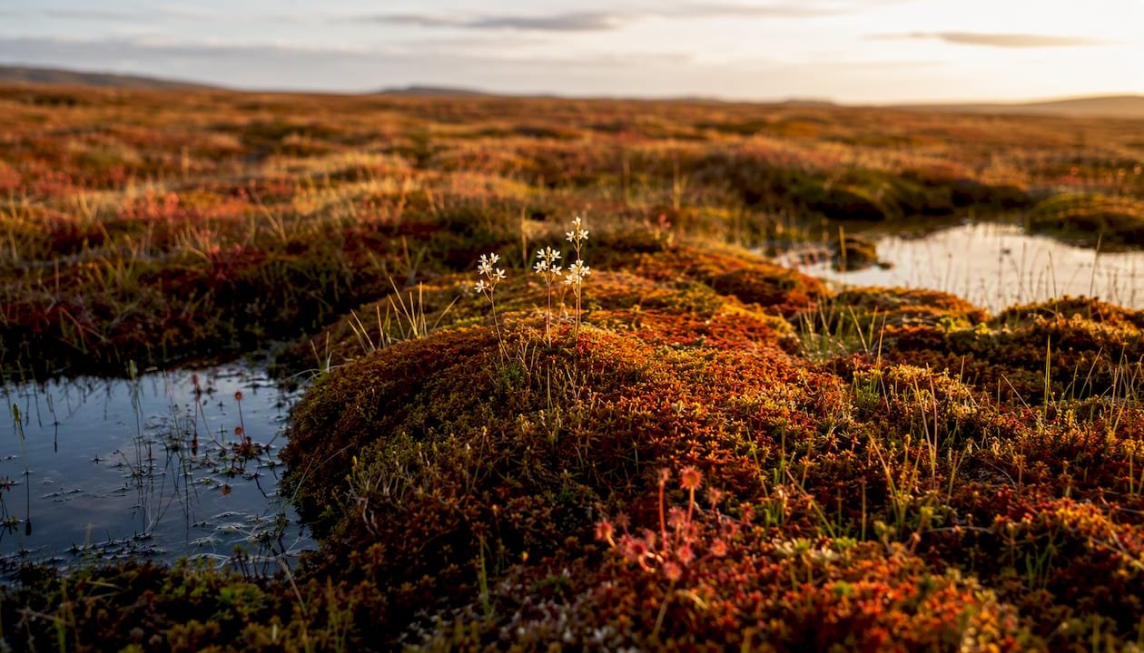
Visually, bog is deceptive: the surface looks flat but is a mosaic of hummocks, pools (dubh lochans) and wet hollows. Sphagnum mosses in red, orange and green dominate. Sundew and bog asphodel add colour in summer. Hen harrier, short-eared owl and golden plover all breed on intact bog.
Peat is a significant carbon store, and damaged bog (drained or burned) releases that carbon. Visitors should stay on boardwalks or firm ground where provided and avoid crossing wet bog off-path.
5. Upland heath and montane grassland
Heather moorland is the most recognisable Highland habitat to most visitors: purple from late July through September, brown and skeletal in winter. It covers vast areas between roughly 300 m and 700 m, shaped by centuries of grazing and managed burning (muirburn). Above the heather zone, montane grassland takes over: mat-grass, deer-grass and, on richer soils, species-rich communities with alpine lady’s mantle and mountain pansy.
In north-west Scotland, montane habitats occur at much lower altitudes than in southern ranges, which shifts the species list and the season. A ridge at 400 m near Torridon can carry the same community as a 900 m ridge in the Cairngorms.
Red grouse are the signature bird of heather moorland. Merlin nest in longer heather. Golden eagle hunt across both heath and grassland, covering enormous territories.
6. Rock outcrop and scree
Exposed bedrock and loose scree are most prominent on the older, harder rocks of the north-west Highlands: Torridonian sandstone, Lewisian gneiss and quartzite produce bold crags, pavements and boulder fields. The Quiraing on Skye and the Storr pinnacles are among the most photographed examples.
Vegetation on rock is sparse but often specialised: roseroot, alpine saxifrages and, on calcareous outcrops, purple saxifrage (one of the earliest Highland flowers, blooming from March). Peregrine falcon nest on cliff faces; ring ouzel favour rocky gullies.
Visitor note: Scree is tiring and ankle-twisting to cross. Quartzite in particular is notoriously slippery when wet.
7. Calcareous grassland and limestone pavement
Less well known than the dramatic summit types, calcareous grassland occurs where base-rich rocks (limestone, marble, shell sand) support a richer flora than the surrounding acid moorland. Limestone pavement, rare in the Highlands but present around Durness and on parts of Skye, supports mountain avens, bloody cranesbill and dark-red helleborine.
These are small, fragile habitats. Limestone pavement is protected under UK law, and walking on the clints (flat rock surfaces) damages the specialist plants growing in the grikes (fissures).
8. Woodlands and riparian strips
Native woodland covers a small fraction of the Highland area today, but remnant Caledonian pinewoods (Black Wood of Rannoch, Rothiemurchus, Glen Affric) and native broadleaf strips along burns are among the most biodiverse habitats in the region. Riparian strips of alder, birch, rowan and willow follow almost every Highland burn and provide shelter, food and nesting habitat for red squirrel, pine marten, wood warbler and common sandpiper.
Ancient pinewoods have a distinctive understorey: juniper, blaeberry, chickweed wintergreen and, in wetter spots, twinflower. The light through old Scots pine is unlike anything in a plantation.
Visitor note: Many native woodland remnants are fenced for deer exclusion. Use gates and close them behind you.
9. Coastal fringes and islands
The Highland coastline stretches from the Solway in the south to Cape Wrath in the north, taking in sea lochs, machair, sea cliffs, sandy beaches and the island landscapes of Skye, Mull and the Summer Isles. The Isle of Skye alone contains several landscape types within a short drive: basalt sea cliffs at Kilt Rock, the machair-fringed beaches of Ord, and the gabbro ridges of the Cuillin.
Machair, the low-lying calcareous grassland found behind Atlantic beaches, is one of Europe’s rarest habitats. It flowers spectacularly from June to August with red clover, yellow rattle and corn marigold. Corncrake call from the longer grass; grey seal haul out on rocky shores year-round.
Summary: landscape types at a glance
| Landscape type | Key landform cues | Representative sites | Best seasons |
|---|---|---|---|
| Mountain summits | Rugged peaks, corries, scree | Ben Nevis, Torridon, An Teallach | June–September |
| Summits and plateaux | Broad ridges, wide horizons | Cairngorms plateau | June–September |
| Glens and straths | Narrow or broad valleys, burns | Glen Affric, Glen Coe, Loch Lomond | April–November |
| Lochs and freshwater | Open water, peat-stained shores | Loch Ness, Loch Maree | April–August |
| Blanket bog and peatland | Flat to rolling, dubh lochans | Flow Country, Rannoch Moor | May–August |
| Upland heath and grassland | Heather, mat-grass, open moorland | Cairngorms, Monadhliath | July–September |
| Rock outcrop and scree | Bold crags, boulder fields | Quiraing (Skye), Torridon | May–October |
| Calcareous grassland | Base-rich turf, limestone pavement | Durness, parts of Skye | June–August |
| Woodlands and riparian | Pine, birch, alder along burns | Glen Affric, Rothiemurchus | April–October |
| Coastal fringes and islands | Sea cliffs, machair, sea lochs | Isle of Skye, Summer Isles | May–August |
Key upland habitats and the wildlife you are likely to find
The JNCC upland habitats summary identifies five principal upland habitat categories across UK highlands: blanket bog, upland heath, inland rock outcrop and scree, mountain heaths and willow scrub, and upland calcareous grassland. Each carries its own species community and its own conservation sensitivity.
Birds to look for by habitat:
- Blanket bog: golden plover, dunlin, hen harrier, short-eared owl, red-throated diver on nearby lochans
- Upland heath: red grouse, merlin, golden eagle (hunting), curlew on lower heath
- Montane grassland and summit heath: ptarmigan, dotterel (on passage and breeding), snow bunting (winter and high summits)
- Rock and scree: peregrine, ring ouzel, raven
- Riparian woodland: common sandpiper, dipper, wood warbler, redstart
Plants that signal habitat type:
- Heather (Calluna vulgaris) and cross-leaved heath: upland heath
- Sphagnum mosses, sundew, bog asphodel: blanket bog
- Cloudberry and crowberry: montane heath and high plateaux
- Mountain avens and purple saxifrage: calcareous rock and grassland
- Scottish primrose (Primula scotica): coastal machair and cliff-top turf in the far north
Seasonal timing shapes what you see. Breeding waders are most visible and vocal from late April through June. Golden eagle display flights peak in February and March. Ptarmigan moult into white winter plumage from October, making them almost impossible to spot against snow. Autumn brings red deer rut to the glens and straths from late September, one of the most dramatic wildlife spectacles in Britain.
Blanket bog and montane communities are particularly sensitive to trampling. Sphagnum moss compresses under repeated foot traffic and takes years to recover. Where boardwalks or flagstone paths exist, use them.
How geology and glaciation shaped the Highland landscape
Glaciation is the single greatest sculptor of the Highland landscape as you see it today, but the rock beneath determined what the ice had to work with. The Highlands sit on some of the oldest rocks in Europe: Lewisian gneiss in the north-west is around 3 billion years old; Caledonian granites and schists dominate the central and eastern ranges. Harder rocks resisted erosion and now form the high ridges; softer bands were scoured into the glens and loch basins that fill with water today.
Variations in rock hardness and long-term landscape evolution produce uneven erosion, waterfalls and shifting watershed divides; practitioners note that mountain landscapes remain geomorphically active long after tectonic uplift has ended.
Research into ancient mountain settings confirms that this process is ongoing: Highland rivers continue to adjust their courses, waterfalls migrate upstream, and corrie headwalls slowly retreat. The landscape is not a finished product.
During the Pleistocene, repeated glaciations carved the corries (armchair-shaped hollows on north and east-facing slopes), deepened the glens into U-shaped troughs, and deposited the moraines and drumlins that now create the lumpy topography of many valley floors. When the ice melted, sea levels rose and flooded the lower glens to create the sea lochs — Loch Duich, Loch Torridon, Loch Broom — that give the west coast its fjord-like character.
The Cairngorms tell a slightly different story: the plateau was high enough to project above the main ice sheet as a nunatak during some glacial phases, which is why its montane communities are older and more diverse than those on peaks that were completely overridden.
Practical advice for visiting different Highland landscape types
Planning a visit across multiple landscape types in one trip requires matching terrain to season, fitness and kit. The notes below are organised by the most common planning decisions.
1. Match your season to the landscape type
Spring (April–May) is best for waterfalls, breeding birds and the first flush of woodland flowers. Summer (June–August) gives the longest days, accessible high ground and flowering machair and bog. Autumn (September–November) brings the best light, red deer rut and vivid heather and birch colour. Winter (December–March) is for experienced hillwalkers only on summits, but coastal and glen landscapes remain accessible and often uncrowded.
2. Check access before you go
Scotland’s Land Reform (Scotland) Act 2003 gives a right of responsible access to most land, but this comes with obligations. The Scottish Outdoor Access Code sets out the detail. Some areas operate seasonal deer management restrictions (typically August–October); check with the relevant estate before heading onto open hill.
3. Carry the right kit for the terrain
Summit and plateau routes require map, compass, waterproofs and spare insulation even in summer. Bog crossings need waterproof boots and patience. Coastal routes can be exposed to sudden Atlantic squalls. For a practical breakdown of terrain-specific preparation, the mountain terrain field guide covers kit and route-finding in detail.
4. Navigate carefully on plateaux
The Cairngorm plateau in particular has claimed lives through navigational errors in whiteout conditions. Compass bearings between waypoints are not optional here. The broad, featureless terrain looks manageable in clear weather and becomes genuinely dangerous in cloud.
5. Protect sensitive habitats
Stay on paths across blanket bog and montane communities. Do not pick plants. Avoid lighting fires on peat (it can smoulder underground for days). Muirburn (controlled heather burning) is a legal land management practice; if you see smoke on a moorland, do not assume it is an emergency unless it is clearly out of control.
Pro Tip: Visit a glen in the morning for low mist and soft light, then drive to a coastal viewpoint for the afternoon. The contrast between enclosed valley and open sea horizon in a single day is one of the most memorable Highland experiences, and it requires no more than 30–40 minutes of driving in most parts of Skye or Wester Ross.
A guide’s perspective on reading the Highland landscape
The most common mistake visitors make is treating the Highlands as a single backdrop rather than a sequence of distinct landscape types. A day that starts in a narrow glen, moves to an open loch shore and finishes at a coastal headland is not just scenic variety for its own sake. Each transition tells a geological story: the glen was carved by ice along a fault line, the loch fills the scoured basin, the headland exposes the ancient gneiss that the ice could not fully remove.
Guides who understand LCT descriptions plan itineraries around these transitions deliberately. The Cairngorms Summits and Plateaux LCT includes landscape perception notes — how the area is experienced visually — which experienced guides use to decide where to pause and interpret a view. That is a different skill from simply knowing where the viewpoint car park is.
Micro-climates matter more than most visitors expect. Mist sits in glens long after the summits clear. The west coast catches Atlantic light in the late afternoon that the east coast never sees. Mountain photography practitioners consistently note that mixing valley-level and summit-level visits in a single day captures the full range of light and atmosphere that makes Highland photography distinctive. The same logic applies to any visitor who wants to understand, not just photograph, the place.
For those interested in how landscape character connects to Highland heritage and cultural identity, the Highland heritage guide sets out the links between terrain, clan history and land use in accessible detail.
See these landscapes with a private guided tour
Covering multiple Highland landscape types in a single trip is straightforward with the right local knowledge. Skyehighlandstours offers private guided tours built around exactly this kind of landscape sequencing, from the Cairngorms plateau to the coastal fringes of Skye and the riparian glens of Wester Ross.

Three practical advantages set a private tour apart from self-guided exploration:
- Routing efficiency: a local guide knows which glen road gives the best morning light and which coastal headland clears of cloud by early afternoon, saving you the guesswork of a first visit.
- Safety and access knowledge: plateau navigation, bog crossings and seasonal deer management restrictions are handled by someone who works in these landscapes year-round.
- Interpretive depth: knowing that the corrie above you was carved by a glacier 12,000 years ago, or that the pinewoods below are a remnant of the original Caledonian forest, changes what you see.
To start planning your itinerary across the landscape types covered in this guide, book a private Highland tour with Skyehighlandstours.
Sources
- Scottish Landscape Character Types Map and Descriptions
- Habitat types: uplands (JNCC)
- Scottish Highlands
FAQ
What is the landscape like in the Scottish Highlands?
The Scottish Highlands combine mountains, peat bog, woodland, heathland, grassland and freshwater in a compact area, producing some of the most varied upland scenery in Europe. Nine principal landscape types, from high plateaux to coastal machair, can be found within a single day’s drive.
What are the main types of highland landscape environment?
The principal types are mountain summits, high plateaux, glens and straths, lochs and freshwater features, blanket bog and peatland, upland heath and montane grassland, rock outcrop and scree, calcareous grassland, woodlands and riparian strips, and coastal fringes and islands.
What is the most iconic landscape in Scotland?
The Cairngorms plateau is the largest area of high ground in Britain and one of the most ecologically significant, while the Cuillin ridge on the Isle of Skye is widely regarded as the most dramatic mountain scenery. Both are covered by NatureScot’s Landscape Character Type framework.
What landforms make the Highlands?
Glaciation carved the Highlands’ corries, U-shaped glens and loch basins during the Pleistocene; variations in rock hardness between ancient Lewisian gneiss, Caledonian granite and softer schists determined which ridges survived and which valleys were scoured deep.
Can a guided tour cover multiple Highland landscape types in one day?
Yes. Skyehighlandstours designs private itineraries that sequence contrasting landscape types, such as a morning glen, a loch shore and a coastal headland, within a single full-day tour, with routing and safety knowledge built in.
Recommended
- Scotland’s mountain terrain types: a field guide for walkers – Skye Highlands Tours
- How to prepare for a highlands adventure – Skye Highlands Tours
- Must-visit spots in the Highlands: your 2026 guide – Skye Highlands Tours
- Highland myth legend locations: the essential visitor guide – Skye Highlands Tours