

Your cart is empty Continue Shopping
Scotland’s mountain terrain types: a field guide for walkers
Scotland’s mountains are a mosaic of high plateaux, corries and ridges, peat-dominated moorland, and exposed inland rock, spread across three distinct topographic regions. NatureScot records that mountains, moors and heaths cover about 60% of Scotland’s land area, while blanket bog alone covers some 1.8 million hectares (around 23% of the land area), making upland terrain the defining character of the country rather than an exception to it. For walkers and students alike, knowing which terrain type you are on changes everything: your kit, your pace, your navigation approach, and your risk profile.
The three regions that organise Scotland’s mountain terrain types are:
- Highlands (north and west of the Highland Boundary Fault): the largest and most varied upland zone, with rugged massifs, deep corries, exposed ridges, and the country’s highest plateaux. Ben Nevis at 1,345 m is the headline, but the character shifts dramatically from the granite Cairngorms in the east to the gabbro Cuillin of Skye in the west.
- Midland Valley (Central Lowlands): lower relief overall, but not flat. Glacially dissected hills, crag-and-tail landforms, and remnant moorland patches sit between the two major fault lines. The terrain here rarely demands mountain skills, but it introduces walkers to the same geological vocabulary.
- Southern Uplands: a broad, rolling dissected plateau south of the Southern Upland Fault, typified by rounded summits, long grassy ridges, and extensive blanket bog. The Merrick in Galloway, at 843 m, is the highest point and a useful benchmark for what this region delivers underfoot.
Ordnance Survey 1:25,000 and 1:50,000 maps remain the standard reference for navigating all three regions, with grid references and contour intervals that reveal terrain shape before you leave the car park.
Key takeaways
Scotland’s mountain terrain types span six principal landform categories across three topographic regions, and knowing which type you are on determines kit, navigation approach, and time planning more than any other single variable.
| Point | Details |
|---|---|
| Three topographic regions | Highlands, Midland Valley, and Southern Uplands each produce distinct terrain signatures for walkers and students. |
| Six core landform types | Plateaux, corries, ridges/arêtes, scree, cliffs/crags, and crag-and-tail are the primary forms to identify on maps and in the field. |
| 60% upland cover | NatureScot records that mountains, moors, and heaths cover about 60% of Scotland’s land area, with blanket bog covering approximately 23% of the country (about 1.8 million hectares). |
| Glaciation shaped the surface | Corries, U-shaped glens, and crag-and-tail hills are Pleistocene legacies; rock type (granite, gabbro, sandstone) determines the detail. |
| Skyehighlandstours guided tours | Private guided tours across the Highlands let walkers experience varied terrain types safely with real-time landscape reading from local guides. |
Table of Contents
- What are the main Scotland mountain terrain types by region?
- How to identify Scotland’s primary mountain landforms in the field
- How upland habitats shape what you walk on
- How glaciation and geology built Scotland’s mountains
- What do Munro, Corbett, Graham, and Marilyn mean?
- Named ranges that show each terrain type at its best
- What each terrain type means for planning, kit, and safety
- Why Scotland’s uplands look wild but often are not
- A local guide’s field checks for reading terrain quickly
- Explore Scotland’s mountain terrains with Skyehighlandstours
- Sources
- FAQ
What are the main Scotland mountain terrain types by region?
Scotland’s three topographic regions each produce a recognisable set of terrain signatures. Understanding those signatures at the regional level is the fastest way to calibrate expectations before a trip.
The Highlands
The Highlands sit above the Highland Boundary Fault and cover the largest share of Scotland’s upland. NatureScot’s Highland Summits landscape character type places the threshold for true highland summit character at around 800 m, above which corries and plateau forms become the dominant landforms. Below that line, the terrain transitions through heather moorland, craggy hillsides, and U-shaped glens carved by ice.
The western Highlands are the most dramatic: steep-sided massifs, narrow ridges, and corries that hold snow well into spring. The eastern Highlands, particularly the Cairngorms, swap that drama for scale. The Cairngorm plateau is one of the largest areas of ground above 1,000 m in Britain, and its granite surface produces a distinctive sub-arctic character, with frost-shattered boulders, montane heath, and exposed rock slabs replacing the heather that dominates lower slopes.
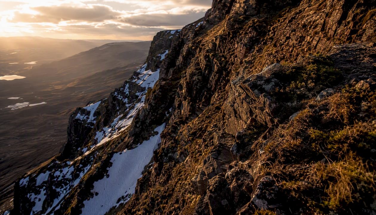
Island terrain adds another layer. The Cuillin of Skye are geologically unlike anything on the Scottish mainland: a narrow, serrated gabbro ridge that demands scrambling skills even on the standard routes. The Outer Hebrides, by contrast, present large-scale, gently undulating peat moorlands with frequent lochans and shallow hills, a terrain type that is boggy and remote rather than technically demanding.
The Midland Valley
The Central Lowlands rarely exceed 600 m, but the terrain is far from uniform. Crag-and-tail landforms, the product of glacial overriding of resistant rock, appear throughout. The Campsie Fells, Ochil Hills, and Lomond Hills all show this character: abrupt northern or western escarpments giving way to gentler dip slopes. Navigation is generally straightforward, but the mix of farmland, forestry, and open moorland means route-finding still requires attention.
The Southern Uplands
The Southern Uplands are often underestimated. NatureScot’s dissected plateau moorland character type notes that these long, rolling ridges look deceptively easy on a map but are energy-draining underfoot because of the repetitive ascent and descent between summits. The dominant vegetation is acid grassland and blanket bog rather than heather, which means the ground is often wetter and less firm than it appears from a distance. Ordnance Survey mapping and NatureScot boundary data are the standard references for confirming which region a planned route falls within.
How to identify Scotland’s primary mountain landforms in the field
Scotland’s upland vocabulary is specific, and knowing what each term means on the ground saves confusion on the hill.
Plateaux and whalebacks are the signature landform of the Cairngorms. The ground above 1,000 m there is broadly flat or gently convex, covered in frost-shattered granite gravel and montane heath. In mist, the absence of obvious slope makes navigation by map and compass non-negotiable.
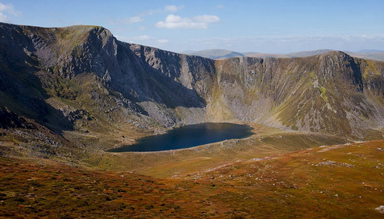
Corries (also written coire in Gaelic, or cwm in Welsh) are armchair-shaped hollows carved by cirque glaciers. The signs are unmistakable: a steep, often cliff-lined backwall, a flattish floor that frequently holds a lochan, and a moraine lip at the mouth. The Cairngorms have some of the finest corrie systems in Britain; the Cuillin of Skye have corries so steep that their backwalls grade directly into technical rock climbs.
Ridges and arêtes are the connective tissue between summits. A ridge is any elongated high ground; an arête is a narrow, knife-edged ridge produced when two adjacent corries erode back-to-back. The Cuillin Main Ridge is the most celebrated arête system in Scotland, but shorter arêtes appear throughout the northwest Highlands wherever corries have bitten into both flanks of a hill.
Scree forms where freeze-thaw cycles shatter exposed rock and the fragments accumulate on slopes below. It is common on the flanks of Torridon sandstone hills and below the Cuillin cliffs. Walking on scree is slow and ankle-testing; descending it fast is tempting but risks a twisted ankle or a fall.
Inland rock, including crags, ledges, and exposed slabs, is ecologically important and a key determinant of route safety. Rocky slopes behave very differently from peat or heather underfoot, and the transition between them can happen within a few metres of horizontal distance.
How upland habitats shape what you walk on
The vegetation and peat beneath your boots tells you as much about the terrain as the contour lines above you. Scotland’s upland habitats fall into four broad categories, each with distinct implications for walking conditions.
- Blanket bog: the most extensive upland habitat in Scotland. Formed where rainfall exceeds evaporation and peat accumulates over centuries, it covers vast areas of the Flow Country in Caithness and Sutherland, the Outer Hebrides, and the wetter parts of the western Highlands. Underfoot, it ranges from firm cotton-grass turf to deep, waterlogged peat hags that can swallow a boot to the knee.
- Dwarf-shrub heath: dominated by heather (Calluna vulgaris), bilberry, and crowberry. FAS Technical Note TN722 distinguishes heath from mire by peat depth: heath sits on peat less than 0.5 m thick, while blanket bog is deeper and waterlogged. Short heather is firm and walkable; old, leggy heather is a different matter entirely, catching ankles and hiding holes.
- Montane grassland: found above the heather line, typically above 700–800 m. Mat-grass (Nardus stricta) and deer-grass dominate on acidic soils. The surface is firmer than bog but can be slippery when wet or frost-covered.
- Inland rock: crags, ledges, and scree. Firm underfoot when dry, treacherous when wet or iced. Ecotones between rock and peat are particularly hazardous because the transition is abrupt and the peat beside a rock slab can be deeply waterlogged.
NatureScot’s upland habitat data confirms that approximately 55% of Scotland is upland, with blanket bog, dwarf-shrub heath, acid grassland, and inland rock making up the bulk of that semi-natural character. The upland mosaic shifts rapidly with slope, aspect, and drainage, so a few metres of horizontal movement can switch you from firm montane grassland to waterlogged peat.
Pro Tip: Before committing to a line across open ground, look for the colour and texture of the vegetation from a distance. Bright green patches in a brown-heather landscape almost always indicate wet ground or a drainage line. Pale straw-coloured grass is usually firmer. Dark, almost black peat hags are visible from 200 m if you know what to look for.
When planning routes across sensitive habitats, responsible travel guidance from Skyehighlandstours covers low-impact practices that protect fragile montane and bog ecosystems.
How glaciation and geology built Scotland’s mountains
Scotland’s terrain is old in its bones and young in its surface. The underlying rock structures date from the Caledonian orogeny, but the shapes walkers see today are largely the product of the last two million years of ice.
Key phases in the formation sequence:
- Caledonian orogeny (roughly 490–390 million years ago): collision of ancient continental plates folded and metamorphosed the rocks that now form the Highlands. The result was a mountain belt comparable in scale to the modern Alps, subsequently eroded to its roots.
- Palaeozoic uplift and erosion: the original Caledonian mountains were worn down over hundreds of millions of years, leaving the resistant metamorphic and igneous rocks that now form the highest ground.
- Pleistocene glaciations (roughly 2.6 million years ago to about 11,700 years ago): repeated advances and retreats of ice sheets and valley glaciers sculpted the terrain into its present form. Scotland’s environment web records that corries, deep lochs, crag-and-tail hills, and U-shaped glens are all Pleistocene legacies.
- Post-glacial peat and soil development: as ice retreated, blanket bog developed across large areas of the uplands, burying earlier glacial deposits under metres of peat in the wettest zones.
The rock type matters as much as the glacial history. Torridon sandstone produces broad, stepped terraces and dramatic cliff faces. Cairngorm granite weathers into rounded tors and frost-shattered gravel plateaux. Skye’s gabbro is so rough that it grips climbing boots like sandpaper, but it fractures into sharp, unstable blocks on the scree below the ridges. Lewisian gneiss, the oldest rock in Britain at around 3,000 million years, forms the low, ice-scoured knolls of the northwest mainland and the Outer Hebrides.
Glacial legacy in numbers: the Pleistocene ice sheets that covered Scotland were, at their maximum, over 1,000 m thick across much of the Highlands. Their retreat left behind not just corries and U-shaped glens but also the raised beaches visible along many coastal cliff lines, where former shorelines now sit metres above present sea level.
What do Munro, Corbett, Graham, and Marilyn mean?
Scotland’s mountain classification system is a product of Victorian and Edwardian hillwalking culture, but it remains the practical language of route planning today.
| Classification | Elevation / prominence threshold | Typical terrain character |
|---|---|---|
| Munro | 3,000 ft or above, separate mountain | Full mountain day; often plateau, corrie, or ridge terrain; navigation skills required |
| Corbett | 2,500–2,999 ft, min. 500 ft drop | Genuine mountain character; less crowded than Munros; varied terrain |
| Graham | 2,000–2,499 ft, min. 150 m drop | Hill rather than mountain in feel; often heather moorland with rocky tops |
| Marilyn | Any height, min. 150 m prominence on all sides | Purely topographic; ranges from sea stacks to major summits |
Mountain Training’s operational definition of mountainous terrain is worth understanding alongside these classifications: the threshold of what counts as “mountainous” for safety and training purposes is not simply about height but about the combination of remoteness, exposure, and technical difficulty. A Corbett in the northwest Highlands can demand more mountain competence than a Munro on a well-worn tourist path.
Common Gaelic place-name elements decode the terrain before you arrive:
- Ben / Beinn: mountain or peak. Almost always indicates a summit of some significance.
- Glen: valley, typically U-shaped and glacially carved.
- Bealach: a mountain pass or col between two summits.
- Brae: a hillside or slope, usually moderate rather than cliff-like.
- Cairn: a pile of stones marking a summit or route; also a rocky hill.
- Coire / Corrie: a mountain hollow or cirque, as described above.
Reading these elements on an Ordnance Survey map gives a working picture of the terrain before the first step.
Named ranges that show each terrain type at its best
Ben Nevis and the Lochaber massif
At 1,345 m, Ben Nevis is the highest point in Britain and a textbook example of montane summit terrain. The tourist path up the south-west flank crosses heather moorland, then montane grassland, then frost-shattered granite boulders near the summit plateau. The north face is a different world: a series of massive cliffs and buttresses rising 600 m from the floor of Coire Leis, managed by the John Muir Trust, which provides site-specific access and hazard guidance. Grid reference NN 166 712 (Ordnance Survey Landranger 41) is the standard map reference for the summit.
The Cairngorms
The Cairngorm massif is the largest area of ground above 1,000 m in Britain and holds the country’s most extensive sub-arctic plateau terrain. The Cairngorms National Park designation covers 4,528 km², and the plateau character, granite gravel, montane heath, and frequent cloud, makes navigation by map and compass essential even in summer. Walkhighlands carries detailed route descriptions for the main approaches, including the Lairig Ghru, one of Scotland’s great mountain passes.
The Cuillin, Isle of Skye
The Black Cuillin is the most technically demanding mountain terrain in Scotland outside of winter. The Main Ridge runs for roughly 12 km and involves sustained scrambling on gabbro, with several sections that require rope work for most walkers. The rock is exceptional, the exposure is serious, and the magnetic gabbro affects compass readings, making GPS a useful supplement rather than a replacement for map skills. The North Highland Tour from Skyehighlandstours includes access to Skye’s landscapes for those who want to see the Cuillin terrain without committing to technical climbing.
Torridon
The Torridon hills in Wester Ross are built from 750-million-year-old Torridonian sandstone, one of the oldest sedimentary sequences in the world. The sandstone produces broad, stepped terraces and dramatic cliff faces, with quartzite caps on several summits giving a distinctive pale colour visible from miles away. Beinn Eighe, partly managed as a National Nature Reserve, is the classic introduction to Torridon terrain. The walking is serious: long approaches, rough ground, and rapid weather changes are the norm.
The Merrick, Galloway
At 843 m, the Merrick is the highest point in the Southern Uplands and a good representative of that region’s terrain. The approach crosses blanket bog and heather moorland before the summit ridge opens into montane grassland. The views are extensive, the terrain is wet underfoot for most of the year, and the navigation is straightforward compared with the northwest Highlands. Walkhighlands carries the standard route description. The Merrick sits within the Galloway Forest Park, which provides access and conservation information.
For a broader picture of how Scotland’s highland glens connect these terrain types, Skyehighlandstours has detailed destination notes on the valley forms that link the ranges above.
What each terrain type means for planning, kit, and safety
Terrain type is the single most useful variable in route planning, more useful than distance and often more useful than total ascent.
Planning checklist by terrain:
- Peatland and blanket bog: waterproof boots as a minimum; gaiters strongly recommended. Route-finding skills matter because paths braid and disappear. Allow extra time: 1 km across deep peat can take as long as 3 km on a good path.
- Heather moorland: ankle support is critical. Old heather hides holes and rocks. Trekking poles reduce fatigue on long traverses.
- Montane grassland: firm but slippery when wet or frosted. Microspikes or crampons in winter. Wind exposure increases significantly above 800 m.
- Scree and talus: slow progress; protect ankles. Descending scree is faster than ascending but carries a higher fall risk.
- Inland rock and crags: sturdy footwear with a stiff sole. Technical scrambling on the Cuillin or Aonach Eagach requires a rope and the skills to use it. Mountain Training’s guidance on what constitutes mountainous terrain is a useful calibration tool for deciding when technical skills become non-negotiable.
Navigation notes:
- On plateau terrain (Cairngorms, Ben Macdui), contour lines are widely spaced and the ground looks similar in all directions. Map, compass, and the ability to take and follow a bearing are essential, not optional.
- On ridges, the terrain itself guides navigation, but cornices in winter can overhang the true edge by several metres. Never assume the visible edge is the safe edge.
- GPS is useful on all terrain but unreliable in deep corries and affected by the magnetic gabbro of the Cuillin. Always carry a paper Ordnance Survey map.
Counting terrain transitions on a planned route, for example: road, enclosed upland, heather moor, scree slope, summit plateau, gives a more accurate time estimate than distance alone. Each transition adds time and effort that a simple distance calculation misses.
Pro Tip: On any route crossing more than two terrain types, build a 20% time buffer into your turnaround calculation. The transition zones between terrain types, where peat meets rock or heather meets scree, are almost always slower than either terrain alone.
For a full kit breakdown matched to Highland terrain, the packing checklist for the Scottish Highlands from Skyehighlandstours covers waterproofs, footwear, and navigation tools by terrain type.
Why Scotland’s uplands look wild but often are not
The apparent wilderness of Scotland’s uplands is partly real and partly a long-term product of human management. NatureScot’s heath and peatland research makes clear that the heather-dominated mosaics covering much of the Highlands and Southern Uplands are shaped by centuries of grazing and controlled burning (muirburn) rather than representing a pre-human baseline.
Scotland holds around 1.8 million hectares of blanket bog, one of the largest concentrations in the world. This habitat stores vast quantities of carbon and supports specialist species including golden plover, dunlin, and sundew. Its extent and condition are directly linked to grazing pressure and burning regimes, both of which remain active management tools across the uplands.
Muirburn rotates burning across heather stands to maintain a mosaic of different age classes. Young heather growth provides food for red grouse; older stands provide cover. For walkers, the practical effect is that heather height and density vary considerably across a hillside, and short-burned heather is noticeably easier to cross than dense, unmanaged stands.
Conservation designations cover a substantial portion of Scotland’s uplands. Sites of Special Scientific Interest (SSSIs), Special Areas of Conservation (SACs), and National Parks (Cairngorms; Loch Lomond and The Trossachs) all carry specific access and land management obligations. Checking NatureScot’s designation data before a visit tells you whether a planned route crosses sensitive habitat and what responsibilities that creates.
Inland rock habitats are small in area but disproportionately important for alpine flora, including rare saxifrages and arctic-alpine mosses. Routes that traverse narrow ledges or rocky outcrops require particular care to avoid damaging species that may have established themselves over decades.
A local guide’s field checks for reading terrain quickly
The difference between a smooth day on the hill and an exhausting one often comes down to reading terrain transitions before committing to a line.
A short checklist of what an experienced guide watches for:
- Peat hag density: visible from the approach as dark, eroded peat walls. High density means slow progress and wet feet regardless of footwear.
- Slope aspect: north and east-facing slopes hold snow and ice longer into spring. The same route that is straightforward in May on a south-facing slope can require crampons on the shaded side.
- Rock stability: on scree and crag terrain, a quick test of a handhold or foothold before weighting it is habit, not caution.
- Path braidedness: multiple parallel paths on a hillside indicate that previous walkers have repeatedly left the original line to avoid wet or eroded ground. The original path is usually the worst option.
The ecotone between heather moorland and montane grassland is one of the most commonly misread transitions. From a distance, the pale grassland above the heather line looks firm and fast. In practice, the transition zone often coincides with a drainage line where water seeps laterally across the slope, and the first 50–100 m of “grassland” can be as wet as the bog below. Committing to a line across that zone without checking the ground first has turned many a planned ridge walk into a knee-deep wade.
When conditions deteriorate, the right call is usually to drop to a lower contour and find the valley floor rather than push across exposed plateau in poor visibility. Local guides who know the specific terrain can read these cues in real time, which is one of the practical advantages of a guided approach on unfamiliar ground.
Explore Scotland’s mountain terrains with Skyehighlandstours
Private guided tours are one of the most efficient ways to cover varied terrain types safely while learning to read the landscape from someone who walks it regularly.

Skyehighlandstours offers private guided tours across the Scottish Highlands, from the gabbro ridges of Skye and the sandstone terraces of Torridon to the granite plateau of the Cairngorms and the rolling moorland of the Southern Uplands. Tours run from half-day excursions to full-day itineraries, with fully customisable routes for families, couples, and small groups. Guides bring terrain knowledge that no map fully conveys: where the peat is deep, which slopes hold ice in April, and which viewpoints show the full range of Scotland’s upland character in a single panorama. To plan a route matched to your fitness level and terrain interests, customise your Highland itinerary directly with the Skyehighlandstours team.
Sources
Authoritative references for maps, habitat data, and route planning:
- Identification of moorland habitats (TN722) — FAS
- Mountains, heaths and bogs — NatureScot
- What is mountainous terrain? — Mountain Training
- Ben Nevis — John Muir Trust
FAQ
What type of terrain does Scotland have?
Scotland’s terrain spans high plateaux, corries, ridges, scree slopes, cliffs, and extensive peat moorland, organised across three regions: the Highlands, the Midland Valley, and the Southern Uplands. NatureScot records that mountains, moors, and heaths cover roughly 60% of the country’s land area.
What are the mountain categories in Scotland?
The main classification categories are Munros (914 m and above), Corbetts (762–914 m with at least 152 m of re-ascent), Grahams (610–761 m), and Marilyns (any height with at least 150 m of prominence on all sides). Each category implies a different level of terrain commitment and remoteness.
What do the Scots call a hillside?
The most common Gaelic term for a hillside or slope is brae, which appears frequently in Scottish place names. Sron (a nose or projecting ridge) and leathad (a slope or hillside) also appear on Ordnance Survey maps in the Highlands.
How does glaciation explain Scotland’s mountain shapes?
Pleistocene ice sheets sculpted corries, U-shaped glens, and crag-and-tail landforms across Scotland over roughly 2.6 million years of advance and retreat. Scotland’s environment web confirms these are the primary geomorphic legacy visible in today’s mountain terrain.
How do I plan a safe route across different Scottish terrain types?
Match kit to terrain (gaiters for peat, stiff soles for rock), carry a paper Ordnance Survey map and compass regardless of GPS, and build a time buffer for terrain transitions. Mountain Training’s guidance on mountainous terrain thresholds is a useful starting point for calibrating when technical skills become necessary.