
Your cart is empty Continue Shopping
Scotland sea kayaking highlights: top routes for paddlers
Scotland’s most rewarding sea kayaking highlights are the Argyll Sea Kayak Trail (sheltered bays and open coast in one continuous route), Staffa and Fingal’s Cave (basalt columns and a sea cave you can paddle into), the Isle of Mull (dramatic cliffs, white-sand beaches, and otters), the Isle of Skye and Inner Sound (mountain backdrops and strong tidal channels), Tiree and Coll (Atlantic surf and turquoise shallows), Loch Linnhe (a 50 km tidal sea loch under Ben Nevis), the Crinan Canal (sheltered beginner paddling linking to the Sound of Jura) and Ganavan Sands near Oban (the trail’s northern start and a practical day-trip base). The RNLI and HM Coastguard both advise filing a float plan and checking tide tables before any sea crossing; Paddle Scotland publishes official route listings and safety guidance for all of these areas.
- Argyll Sea Kayak Trail — a long multi-day route from Ganavan to Helensburgh; best for mixed-ability groups wanting a structured multi-day route with clear access points
- Staffa and Fingal’s Cave — paddling directly into the hexagonal basalt cave; best for photographers and geology enthusiasts
- Gulf of Corryvreckan — the world’s third-largest whirlpool; advanced paddlers only, timed to slack water
- Falls of Lora — a tidal waterfall beneath Connel Bridge; best for experienced paddlers who want a white-water feature on a sea kayak trip
- Isle of Mull — sea caves, arches, white beaches, and regular otter sightings; suits intermediate paddlers and guided groups
- Isle of Skye and Inner Sound — mountain scenery, strong tidal flows, and white-tailed eagle territory; intermediate to advanced
- Tiree and Coll — Atlantic-facing beaches, consistent surf, and crystal-clear water; suits confident beginners to intermediate paddlers
- Loch Linnhe — sheltered loch paddling with Ben Nevis as a backdrop; beginner-friendly sections near Fort William
- Crinan Canal — flat-water paddling through Argyll’s countryside; ideal for beginners and families
- Ganavan Sands, Oban — easy beach launch, ferry connections to the islands, and a gateway to the Firth of Lorn
Key takeaways
Scotland’s sea kayaking highlights span everything from sheltered beginner canals to advanced tidal races, and the single most important planning step is always the tide table, not the weather forecast.
| Point | Details |
|---|---|
| Choose your region by skill level | Beginners suit Crinan Canal and upper Loch Linnhe; advanced paddlers target Corryvreckan and Kyle Rhea. |
| Plan tides before weather | Tidal streams at Corran Narrows and the Gulf of Corryvreckan can exceed 4 knots; always identify the slack-water window first. |
| The Argyll Sea Kayak Trail is the benchmark route | At c.150 km from Ganavan to Helensburgh, it suits day trips or multi-day expeditions and covers the best of Argyll’s coast. |
| Pack for immersion, not just rain | Water temperature rarely exceeds 15°C in summer; a drysuit or 5 mm wetsuit is the minimum for Scottish sea conditions. |
| A local guide adds irreplaceable value | Precise slack-water timing, hidden landings, and wildlife hotspots are knowledge that no guidebook fully captures. |
Table of Contents
- What makes sea kayaking in Scotland different from anywhere else?
- Scotland’s top sea kayaking highlights at a glance
- Region-by-region guide: routes, launch points, and local hazards
- How do you plan around tides and tidal hazards in Scotland?
- Trip types and sample itineraries
- What kit do you need for sea kayaking in Scottish waters?
- Why does a local guide make a real difference on Scottish waters?
- Sources
- FAQ
What makes sea kayaking in Scotland different from anywhere else?
Scotland’s west coast offers a range of paddling conditions that few places on earth can match in such a compact geography. Within a single day’s drive from Glasgow or Inverness, you can move from flat-water canal sections to exposed tidal races that demand real technical skill. The west coast from Oban to the Hebrides is widely regarded as the prime area because it combines sheltered inlets with open tidal channels and exceptional island paddling.
The dominant variables are tides and weather, not raw paddling fitness. Wind can shift from Force 2 to Force 6 in under an hour on the exposed Hebridean crossings, and tidal streams in the Corryvreckan or at the Corran Narrows run faster than most paddlers expect. Experienced paddlers who underestimate these conditions get into trouble; beginners who plan carefully with a guide often have their best-ever days on the water.
Skill tiers, seasons, and typical conditions
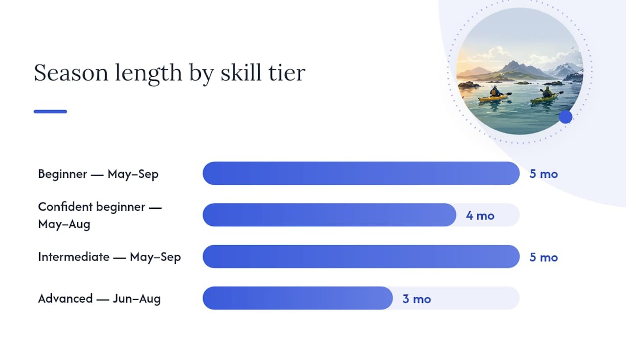
| Skill tier | Typical conditions | Recommended season | Suggested areas |
|---|---|---|---|
| Beginner | Sheltered lochs, canals, calm bays | May–September | Crinan Canal, Ganavan Sands, Loch Linnhe (Fort William end) |
| Confident beginner | Sheltered sea lochs, short coastal hops | May–August | Mull (sheltered east coast), Loch Linnhe, Tiree (calm days) |
| Intermediate | Open coast, short crossings, moderate tidal streams | May–September | Mull circuit, Skye east coast, Argyll Sea Kayak Trail sections |
| Advanced | Exposed crossings, strong tidal races, multi-day expeditions | June–August | Gulf of Corryvreckan, Inner Sound, Falls of Lora, Summer Isles |
May to August gives the longest daylight, calmest average seas, and the best wildlife-viewing windows. Puffins are present at Staffa from late April through July. Basking sharks appear off Coll and Tiree from June. Autumn brings rougher conditions but spectacular light and fewer boats. Winter paddling is for the experienced only: short days, cold water, and rapidly changing weather demand full expedition preparation.
Scotland’s top sea kayaking highlights at a glance
These are the places that come up again and again when experienced paddlers discuss the highlights of Scottish coastline. Each entry covers what makes it special, who it suits, and any hazard worth knowing before you launch.
- Argyll Sea Kayak Trail — a c.150 km waymarked route from Ganavan Sands near Oban south to Helensburgh, passing sea lochs, the Crinan Canal, and open Firth of Clyde coast. Best for paddlers who want a structured, multi-day adventure with clear access points and the option to dip in for a single day. Intermediate skill level for the full route; some sections suit beginners.
- Staffa and Fingal’s Cave — paddling into the cave mouth at sea level, surrounded by perfectly formed basalt columns, is one of the most iconic sea-kayaking experiences in Scotland. Best for photographers and anyone drawn to dramatic geology. The crossing from Mull is weather-dependent; plan for a calm, settled day.
- Falls of Lora — a tidal waterfall under Connel Bridge at the mouth of Loch Etive, where the ebbing tide creates standing waves and a fast tidal race. Best for experienced paddlers who want a white-water challenge within a sea-kayak context. Dangerous at peak flow; time your visit to the early stages of the ebb.
- Gulf of Corryvreckan — the strait between Jura and Scarba generates one of the world’s most powerful tidal whirlpools. Argyll’s tidal highlights include this and the Falls of Lora as the two most demanding features on the west coast. Advanced paddlers only, timed precisely to slack water.
- Isle of Mull — sea caves, natural arches, white-sand beaches at Calgary Bay, and one of the best places in Scotland to spot otters from a kayak. Suits intermediate paddlers; the sheltered east coast around Salen and Craignure is accessible to confident beginners.
- Tiree — Atlantic-facing beaches with some of the clearest water in Scotland, consistent surf on the west side, and a flat, low-lying coastline that gives long views in every direction. Best for confident beginners to intermediate paddlers; the surf beaches suit those wanting to practise in open-water conditions.
- Loch Linnhe — a tidal sea loch of around 50 km with Ben Nevis as a backdrop and practical launch points at Caol and Corpach near Fort William. The sheltered upper loch suits beginners; the Corran Narrows further south demand respect.
- Crinan Canal — flat-water paddling through Argyll’s countryside, connecting Ardrishaig on Loch Fyne to Crinan on the Sound of Jura. Described as Britain’s most beautiful shortcut, it is ideal for beginners and families, and links directly to more exposed coastal routes.
- Isle of Skye and Inner Sound — the Inner Sound between Skye and the mainland offers mountain scenery, white-tailed eagle sightings, and strong tidal flows. The National Trust for Scotland runs ranger-led expeditions here for a range of abilities, including multi-day trips to the Isle of Canna and the Outer Hebrides.
- Ganavan Sands, Oban — a sheltered beach launch just north of Oban town, the official northern start of the Argyll Sea Kayak Trail, and a practical base for day trips to Kerrera, Lismore, and the Firth of Lorn. Suits all abilities as a launch point.
Region-by-region guide: routes, launch points, and local hazards
Argyll and the Isles
Argyll is the heartland of sea kayaking in Scotland. The variety here is unmatched: sheltered sea lochs, the Crinan Canal, open Firth of Clyde coast, and the tidal drama of Corryvreckan and the Falls of Lora. Wildlife includes common and grey seals, harbour porpoise, gannets, and, in summer, basking sharks.
- Launch points: Ganavan Sands (Oban), Crinan, Ardrishaig, Tarbert
- Skill level: Beginner (canal, sheltered lochs) to advanced (Corryvreckan, Falls of Lora)
- Signature sights: Gulf of Corryvreckan, Falls of Lora, Crinan Canal, Jura coastline
- Main hazards: Corryvreckan tidal race (plan to slack water only); Falls of Lora ebb tide; exposed crossings to Jura and Islay in strong westerlies
- Access: A816 from Oban to Crinan; ferry from Kennacraig to Islay and Jura (CalMac)
- Hire and guides: Local kayak hire and guided day trips available in Oban; guided multi-day tours operate from Crinan and Tayvallich
Isle of Mull and Iona
Mull’s coastline runs to roughly 480 km, making it one of the most varied single-island paddles in Scotland. The sheltered east coast from Craignure north to Tobermory suits intermediate paddlers; the exposed west coast around Loch na Keal and Calgary Bay is more demanding. Iona, a short crossing from Fionnphort, adds a historic and scenic destination to a south-Mull circuit.
- Launch points: Craignure, Tobermory, Salen, Fionnphort
- Skill level: Intermediate (east coast); advanced (west coast and exposed crossings)
- Signature sights: Calgary Bay, Staffa crossing, Iona, sea caves near Gribun
- Main hazards: Exposed west coast in any westerly swell; Staffa crossing weather-dependent
- Access: CalMac ferry from Oban to Craignure (45 minutes); ferry from Fionnphort to Iona
- Hire and guides: Kayak hire available in Tobermory; guided day trips and multi-day tours operate from several bases on the island
Isle of Skye and the Inner Sound
The Inner Sound, between Skye’s east coast and the mainland peninsula of Applecross, is one of the most scenically dramatic stretches of sea kayaking in Scotland. White-tailed eagles are a regular sight overhead; the tidal streams run at up to 4 knots at springs through the Kyle Rhea narrows. The NTS offers ranger-led sea-kayaking expeditions from Kintail to Skye, Canna, and the Outer Hebrides for a range of abilities.
- Launch points: Kyleakin, Broadford, Portree, Kylerhea (for Kyle Rhea crossing)
- Skill level: Intermediate to advanced (tidal streams at Kyle Rhea require careful timing)
- Signature sights: Cuillin mountain backdrop, white-tailed eagles, Raasay, Kyle Rhea narrows
- Main hazards: Kyle Rhea tidal race (up to 8 knots at springs); exposed north and west coasts of Skye in any swell
- Access: A87 to Kyle of Lochalsh; Skye Bridge; CalMac ferry from Mallaig to Armadale
- Hire and guides: Guided sea-kayaking operators based in Broadford and Portree; day hire available
Tiree and Coll
Tiree is the sunniest island in the UK by average hours and has some of the clearest water on the west coast. The flat, low-lying coastline means you are never far from a beach landing. Coll, just to the north-east, is quieter and wilder, with rocky headlands and sandy bays. Both islands face the full Atlantic on their western shores, so surf and swell are a real factor.
- Launch points: Scarinish (Tiree), Arinagour (Coll)
- Skill level: Confident beginner to intermediate (sheltered east sides); intermediate to advanced (west-facing beaches in swell)
- Signature sights: Balephuil Bay, Hynish, Breachacha Castle (Coll), Atlantic surf beaches
- Main hazards: Atlantic swell on west-facing coasts; limited shelter in strong westerlies
- Access: CalMac ferry from Oban (3.5 hours to Tiree); short hop from Tiree to Coll
- Hire and guides: Limited local hire; most paddlers bring their own kit or join guided tours from Oban
Crinan Canal and Kintyre
The Crinan Canal is 14.5 km of flat water through Argyll’s countryside, with 15 locks and views of the hills above Knapdale. It is the gentlest introduction to paddling in Argyll and connects directly to the Sound of Jura at the western end, where conditions change dramatically. The Kintyre peninsula to the south has exposed west-coast paddling and sheltered east-coast options on Kilbrannan Sound.
- Launch points: Ardrishaig (east end), Crinan (west end), Tarbert
- Skill level: Beginner (canal); intermediate to advanced (Sound of Jura and Kintyre west coast)
- Signature sights: Canal locks, Crinan village, Sound of Jura, Mull of Kintyre
- Main hazards: Sound of Jura tidal streams; exposed Kintyre west coast
- Access: A816 from Lochgilphead; ferry from Kennacraig to Islay
- Hire and guides: Canoe and kayak hire available at Ardrishaig and Crinan
Oban and Ganavan Sands
Ganavan Sands sits just north of Oban and is the official northern start of the Argyll Sea Kayak Trail. The beach launch is easy, the ferry connections from Oban give access to Mull, Lismore, Kerrera, and the Firth of Lorn, and the town has everything you need for provisioning a multi-day trip.
- Launch points: Ganavan Sands, North Pier Oban
- Skill level: All abilities (sheltered bay launch); intermediate for open Firth of Lorn crossings
- Signature sights: Kerrera, Lismore lighthouse, Dunollie Castle from the water
- Main hazards: Ferry traffic in the Sound of Kerrera; tidal streams in the Firth of Lorn
- Access: A85 to Oban; CalMac ferries from Oban to multiple islands
- Hire and guides: Kayak hire and guided day trips available in Oban
Loch Linnhe and Fort William
Loch Linnhe is a tidal sea loch running roughly 50 km from Fort William south-west to Lismore. The upper loch near Fort William is sheltered and beginner-friendly, with Ben Nevis and the Mamores as a backdrop. The Corran Narrows, about 16 km south of Fort William, pinch the loch to around 500 m and generate fast tidal streams. The Corran Ferry crosses here and is a useful logistical reference point for planning a south-bound paddle.
- Launch points: Caol, Corpach (near Fort William), Onich (south of Corran Narrows)
- Skill level: Beginner (upper loch); intermediate to advanced (Corran Narrows and south)
- Signature sights: Ben Nevis from the water, Corran Lighthouse, Ardgour hills
- Main hazards: Corran Narrows tidal streams; ferry traffic at the narrows crossing
- Access: A82 from Fort William; Corran Ferry for the south shore
- Hire and guides: Kayak hire available in Fort William; guided tours operate from the town
North-west Scotland and the Summer Isles
The Summer Isles, Scourie, and Kylesku are among the least-paddled stretches of Scotland’s coast. The geology here is ancient Lewisian gneiss, the birdlife is exceptional (Handa Island is a major seabird reserve), and the sense of remoteness is genuine. Facilities are minimal: you will need wild-camping skills, full self-sufficiency, and a longer drive to reach the put-in points. The reward is a coastline that feels genuinely untouched.
- Launch points: Achiltibuie (Summer Isles), Scourie, Kylesku
- Skill level: Advanced (remote, limited rescue cover, exposed crossings)
- Signature sights: Summer Isles, Handa Island seabird stacks, Eas a’ Chual Aluinn waterfall from the sea
- Main hazards: Remote location, limited mobile signal, exposed crossings, rapidly changing weather
- Access: A835 to Ullapool, then minor roads; long drive from central Scotland
- Hire and guides: Very limited local hire; guided expeditions strongly recommended
Region comparison
| Region | Best for | Skill level | Typical duration | Access town | Best season | Main hazards |
|---|---|---|---|---|---|---|
| Argyll and the Isles | Mixed paddling, wildlife, tidal features | Beginner–advanced | Day | Oban | May–September | Corryvreckan, Falls of Lora |
| Isle of Mull and Iona | Sea caves, wildlife, island circuit | Intermediate–advanced | 2–5 days | Craignure/Tobermory | May–August | West coast swell, Staffa crossing |
| Skye and Inner Sound | Mountain scenery, eagles, tidal channels | Intermediate–advanced | 2 days | Broadford/Portree | June–August | Kyle Rhea tidal race |
| Tiree and Coll | Surf, clear water, Atlantic beaches | Confident beginner–intermediate | 2–4 days | Scarinish | June–August | Atlantic swell |
| Crinan Canal and Kintyre | Beginners, sheltered paddling | Beginner–intermediate | Half-day to 2 days | Ardrishaig/Crinan | April–October | Sound of Jura tidal streams |
| Oban and Ganavan | Day trips, trail start, island access | All abilities | Day to 3 days | Oban | May–September | Firth of Lorn tidal streams |
| Loch Linnhe | Scenic loch paddling, Ben Nevis views | Beginner–advanced | Day to 3 days | Fort William | May–September | Corran Narrows |
| North-west and Summer Isles | Remote wilderness, geology, birdlife | Advanced | 5 days | Ullapool/Achiltibuie | June–August | Remoteness, exposed crossings |
How do you plan around tides and tidal hazards in Scotland?
Tides and wind are the dominant risk in Scottish sea kayaking. Plan the tide first; then check the weather. A paddler who reverses that order will eventually find themselves fighting a 4-knot stream in a rising wind with no abort point in sight.
Planning checklist for any tidal crossing or hazardous feature
- Download or print tide tables for the specific location (not just the nearest port; secondary port corrections matter on the west coast)
- Check the tidal stream atlas for the area, not just the height tables
- Identify the slack-water window and plan to be on the water 30 minutes before it
- Check the RNLI and HM Coastguard forecasts for wind strength and direction on the day
- File a float plan with a shore contact: your route, expected finish time, and what to do if you do not check in
- Identify abort points before you launch: where can you land safely if conditions deteriorate?
- Carry a VHF radio and know Channel 16; mobile signal is unreliable on many west-coast stretches
Named tidal hazards to know
Gulf of Corryvreckan sits between Jura and Scarba. The tidal stream floods north-east and ebbs south-west through a narrow channel over an underwater pinnacle, generating a standing wave and whirlpool that can reach several metres in height at springs. Slack water lasts only minutes. This is an advanced-only feature; even experienced paddlers treat it with considerable caution.
Falls of Lora forms at the mouth of Loch Etive under Connel Bridge. The loch’s restricted entrance means the ebbing tide creates a tidal waterfall and standing waves. At peak ebb the feature is dangerous for any kayaker; the early stages of the ebb or the flood offer a manageable challenge for experienced paddlers.
Corran Narrows on Loch Linnhe pinch the loch to around 500 m. Tidal streams here run fast at springs and the Corran Ferry crosses the narrows, adding vessel traffic to the hazard. Time your crossing to slack water and stay well clear of the ferry lane.
Pro Tip: Always carry a printed tide table as a backup. Phone batteries die and signal disappears exactly when you need the data most. The UKHO EasyTide service and Reeds Nautical Almanac are the standard references for west-coast Scotland.
Trip types and sample itineraries
Sea kayaking in Scotland suits everything from a two-hour taster paddle to a ten-day wilderness expedition. The four main formats are: a guided day trip (no prior experience needed, guide handles tides and navigation), a self-guided day (your own kit, your own planning), a 2–3 day mini-expedition (camping or B&B, one or two island crossings), and a multi-day trail section such as the Argyll Sea Kayak Trail.
Day trip from Ganavan Sands, Oban — Launch from Ganavan, paddle south around the north tip of Kerrera (roughly 12 km return), land on Kerrera for lunch, return on the flood. Suitable for confident beginners with a guide. Allow 4–5 hours on the water.
Two-day Mull east coast circuit — Ferry from Oban to Craignure. Day one: paddle north from Craignure to Tobermory (roughly 25 km), camping or B&B overnight. Day two: return south or take the ferry back. Intermediate skill level. The sheltered Sound of Mull keeps conditions manageable in most summer weather.
Three-day south Mull and Staffa — Base at Fionnphort. Day one: paddle the south Mull coast to Loch Buie. Day two: cross to Staffa in settled conditions (roughly 12 km from Fionnphort; weather-dependent as Condé Nast Traveller notes), explore Fingal’s Cave, return. Day three: cross to Iona and back. Intermediate to advanced; the Staffa crossing requires a settled forecast.
Three-to-five day Argyll Sea Kayak Trail section — The full trail is c.150 km; a manageable first section runs from Ganavan south through the Crinan Canal to Crinan (roughly 60–70 km over 3–4 days), combining sheltered loch paddling, the canal, and short coastal hops. Intermediate skill level for the coastal sections. Camping is possible at several points; book ahead in July and August.
Two-day Loch Linnhe paddle — Launch from Caol near Fort William. Day one: paddle south-west along the north shore of Loch Linnhe, aiming for Onich (roughly 16 km). Day two: return or continue south towards the Corran Narrows, timing the narrows crossing to slack water. Beginner-friendly on day one; the narrows require intermediate skill. Ben Nevis is visible for most of the route.
Multi-day logistics notes: Wild camping is legal in Scotland under the Land Reform (Scotland) Act 2003, but Leave No Trace practice is expected. Carry all waste out, use a trowel for human waste well above the high-water mark, and avoid camping in the same spot two nights running on popular stretches. Book CalMac ferries in advance for July and August, particularly for vehicles. Resupply options are limited outside Oban, Tobermory, and Fort William; plan food for the full section.
What kit do you need for sea kayaking in Scottish waters?
Clothing, buoyancy, communication, and waterproof storage are non-negotiable in Scottish seas. The water temperature off the west coast rarely exceeds 15°C even in August; cold-water shock and hypothermia are realistic risks if you capsize without the right kit.
Essential kit checklist
- Buoyancy aid or PFD — worn at all times on the water; a sea-kayak-specific model with pockets for VHF and snacks
- Spraydeck — essential for any open-water or tidal paddling; a neoprene deck for rougher conditions
- Drysuit or wetsuit — a drysuit is strongly recommended for Scottish sea conditions; a 5 mm wetsuit is the minimum for summer paddling
- VHF radio — handheld, waterproof, programmed to Channel 16; a PLB (personal locator beacon) for remote trips
- Paddle float and bilge pump — for self-rescue after a capsize
- Tow line — for assisting a paddler in difficulty
- First aid kit — waterproof, including blister treatment and hypothermia foil blanket
- Navigation — waterproof chart, compass, and tide tables; GPS as a backup
- Repair kit — duct tape, split-paddle sleeve, and a basic hull repair patch
- Dry bags — for sleeping kit, food, and spare clothing on multi-day trips
- Flares — at minimum two hand flares and a parachute rocket for offshore paddling
Hire versus guided trip: a quick decision framework
Hire your own kit if you have sea-kayak experience, can read tide tables confidently, and are paddling a route you know or have researched thoroughly. Book a guided trip if any of the following apply: you are new to sea kayaking, the route involves tidal races or exposed crossings, your group has mixed abilities, or you want to maximise wildlife-spotting opportunities. A guide’s local knowledge of precise landing spots, slack-water windows, and wildlife hotspots adds value that no guidebook fully replicates.
When choosing a hire provider, ask: what is included in the hire (spraydeck, buoyancy aid, paddle); what is the cancellation policy in poor weather; and is there a safety briefing before launch.
Pro Tip: Pack a dry change of clothes in a separate dry bag and leave it in the car or at your accommodation. After a long day on the water in Scottish conditions, getting warm and dry quickly matters more than any piece of kit you carried on the boat.
Why does a local guide make a real difference on Scottish waters?
A local guide is worth booking when tides, remoteness, or wildlife-viewing windows are central to your trip. The reason is specific: local guides know the precise slack-water timing for a given location on a given day, the exact landing beaches that are sheltered in a south-westerly, and where the otters are most reliably seen at low tide. That knowledge does not appear in any guidebook.
Scottish sea kayaking professionals consistently note that guidebooks are excellent references but cannot substitute for on-water local expertise when it comes to safe landings, slack-water timing, and wildlife hotspots. The gap between a guidebook description and the reality of a specific tidal feature on a specific day can be significant.
The National Trust for Scotland runs ranger-led sea-kayaking days and multi-day expeditions from Kintail to destinations including Skye, the Isle of Canna, and the Outer Hebrides, covering a range of abilities from taster days to seven-day expeditions. These trips extend access to remote islands and coasts that would be logistically challenging to reach independently.
When a guide changes the plan
- Narrow slack windows at the Gulf of Corryvreckan or Kyle Rhea: a guide knows the precise timing; a first-time visitor is guessing
- Uncertain weather on an exposed crossing: a guide can read local conditions and has abort-point knowledge built in
- Wildlife viewing: guides know the reliable otter holts, eagle roost trees, and puffin colony timings that are not on any map
Booking checklist for a guided sea-kayak trip
- Confirm the guide holds a British Canoeing Sea Kayak Leader award or equivalent
- Check the guide-to-paddler ratio (no more than 6:1 for tidal or exposed routes)
- Ask about public liability insurance and what it covers
- Confirm the cancellation and rebooking policy for poor weather
- Ask what kit is provided and what you need to bring
- Check whether the trip is graded and whether it matches your experience level
Skyehighlandstours offers private guided tours and customisable itineraries across the Highlands, including coastal and island destinations, and can help you plan a guided experience that combines sea-level highlights with the wider Highland landscape. For readers who want a fully tailored trip, the Scottish Highlands destination page is a practical starting point.
What paddling Scotland’s coast actually feels like
Paddling into Fingal’s Cave at sea level, with the basalt columns rising above you and the swell lifting the hull gently against the rock, is one of those moments genuinely hard to describe to someone who has not done it. The cave amplifies sound in a way that makes the sea feel enormous and intimate at the same time. Equally memorable, in a quieter way, is an early morning on Loch Linnhe when Ben Nevis is perfectly mirrored in the water and there is no wind at all. You paddle in near-silence for an hour and see nothing but mountains and a grey heron lifting off a rock.
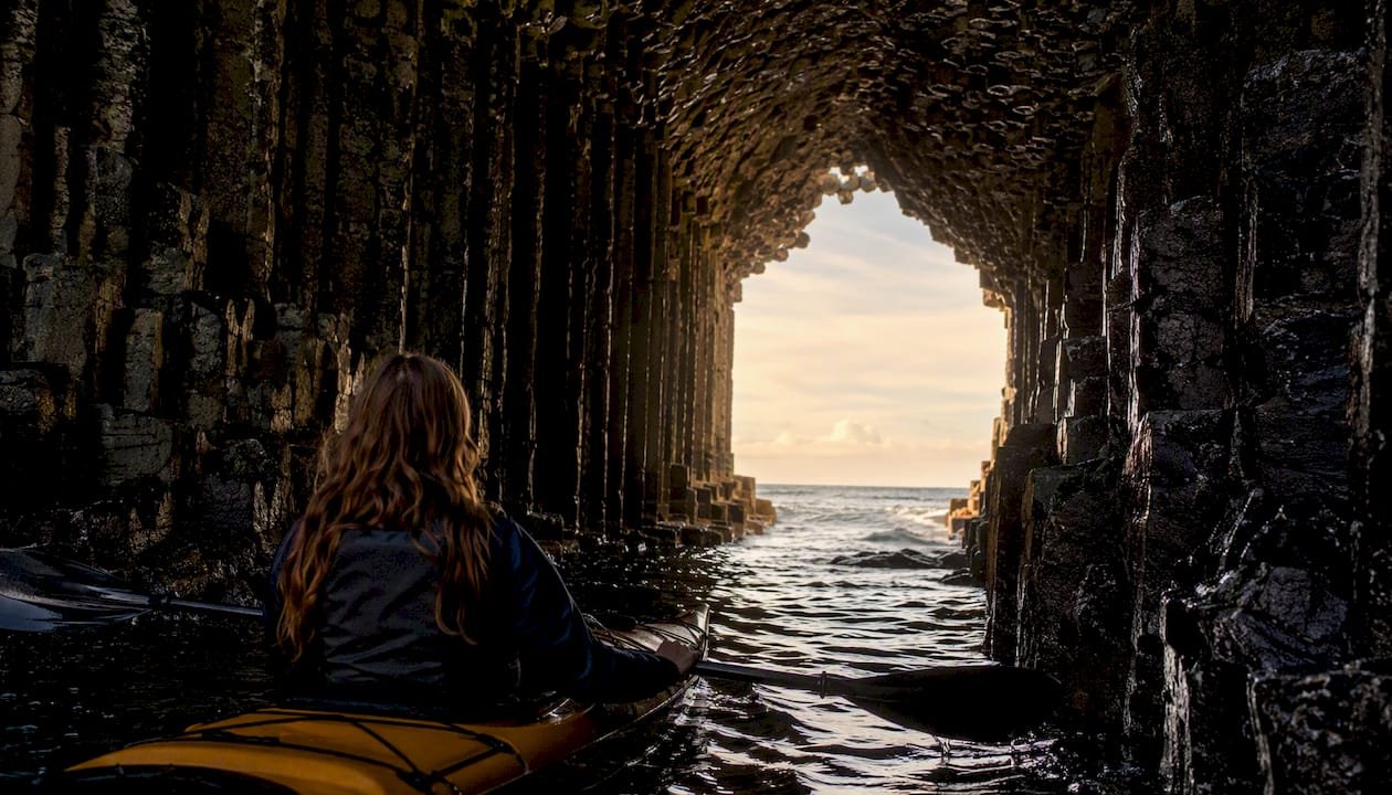
What the photographs do not show is the planning that makes those moments possible. The Staffa crossing requires a settled forecast and a tide that is running in your favour. The Loch Linnhe morning requires an early start before the sea breeze builds. Scotland rewards paddlers who do the homework. It also rewards those who leave the coast as they found it: carry out everything you carry in, keep a respectful distance from seal haul-outs and nesting birds, and follow Leave No Trace principles on every overnight stop. The coastline is extraordinary precisely because it has been treated well.
Sources
- Paddling Trails | Paddle Scotland
- Loch Linnhe — sea kayaking under Ben Nevis | TripSCOT
- Kayaking in Argyll | Scotland’s Adventure Coast
- Sea kayaking | Kintail highlights | National Trust for Scotland
- A Guide to Kayaking in Scotland: From Lochs to Wild Coastlines | LTR Castles
- Kayak along Scotland’s whisky coast
FAQ
What is the best area for sea kayaking in Scotland?
The west coast from Oban to the Hebrides is widely regarded as the best area, combining sheltered inlets with exposed tidal channels, exceptional wildlife, and island paddling. Argyll, Mull, Skye, and Tiree are the most popular destinations.
How difficult is the Gulf of Corryvreckan for kayakers?
The Gulf of Corryvreckan is an advanced-only feature. The tidal whirlpool and standing waves require precise slack-water timing and strong open-water skills; it is not suitable for beginners or intermediate paddlers without an experienced guide.
How long is the Argyll Sea Kayak Trail?
The Argyll Sea Kayak Trail runs approximately 150 km between Ganavan Sands near Oban and Helensburgh. It can be paddled in sections as day trips or completed as a multi-day expedition.
When is the best time of year to sea kayak in Scotland?
May to August offers the calmest average sea conditions, longest daylight hours, and the best wildlife-viewing windows, including puffins at Staffa and basking sharks off Tiree. June and July are generally the most settled months.
Do I need a guide for sea kayaking in Scotland?
A guide is strongly recommended for tidal features such as the Gulf of Corryvreckan and Kyle Rhea, remote routes in the north-west, and for anyone new to sea kayaking. Sheltered routes such as the Crinan Canal and upper Loch Linnhe are manageable for confident beginners without a guide.
1 Comment